
Goodrich topographic map
Interactive map
Click on the map to display elevation.
About this map
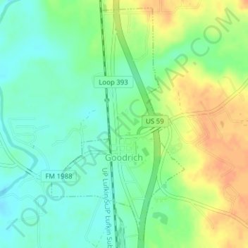
Name: Goodrich topographic map, elevation, terrain.
Location: Goodrich, Polk County, Texas, United States (30.59649 -94.95576 30.62177 -94.93893)
Average elevation: 38 m
Minimum elevation: 22 m
Maximum elevation: 58 m
Other topographic maps
Click on a map to view its topography, its elevation and its terrain.
Livingston
United States > Texas > Polk County
Livingston, Polk County, Texas, United States
Average elevation: 63 m
Tobacco Patch
United States > Texas > Polk County
Tobacco Patch, Polk County, Texas, United States
Average elevation: 43 m
Israel
United States > Texas > Polk County
Israel, Polk County, Texas, United States
Average elevation: 87 m
Seven Oaks
United States > Texas > Polk County
Seven Oaks, Polk County, Texas, United States
Average elevation: 68 m