
Thank you for supporting this site ❤️
Make a donation
Make a donation
Le Lay topographic map
Click on the map to display elevation.
Thank you for supporting this site ❤️
Make a donation
Make a donation
About this map
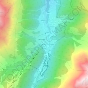
Name: Le Lay topographic map, elevation, terrain.
Average elevation: 1,565 m
Minimum elevation: 1,060 m
Maximum elevation: 2,542 m
Thank you for supporting this site ❤️
Make a donation
Make a donation
Other topographic maps
Click on a map to view its topography, its elevation and its terrain.
74170
France > Auvergne-Rhône-Alpes > Haute-Savoie > Les Contamines-Montjoie
Average elevation: 1,556 m
Glacier de Tré-la-Tête
France > Auvergne-Rhône-Alpes > Haute-Savoie > Les Contamines-Montjoie
Average elevation: 3,031 m