
Wolfsdonk topographic map
Interactive map
Click on the map to display elevation.
About this map
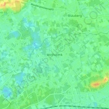
Name: Wolfsdonk topographic map, elevation, terrain.
Average elevation: 17 m
Minimum elevation: 8 m
Maximum elevation: 37 m
Other topographic maps
Click on a map to view its topography, its elevation and its terrain.
Aarschot
België > Vlaams-Brabant > Leuven > Aarschot
Aarschot, Leuven, Vlaams-Brabant, Vlaanderen, België
Average elevation: 26 m
Rillaar
België > Vlaams-Brabant > Leuven > Aarschot
Rillaar, Aarschot, Leuven, Vlaams-Brabant, België
Average elevation: 28 m
Langdorp
België > Vlaams-Brabant > Leuven > Aarschot
Langdorp, Aarschot, Leuven, Vlaams-Brabant, Vlaanderen, 3201, België
Average elevation: 17 m
Gelrode
België > Vlaams-Brabant > Leuven > Aarschot
Gelrode, Aarschot, Leuven, Vlaams-Brabant, België
Average elevation: 30 m
Ourodenberg
België > Vlaams-Brabant > Leuven > Aarschot
Ourodenberg, Aarschot, Leuven, Vlaams-Brabant, Vlaanderen, 3200, België
Average elevation: 16 m