
Mourgues topographic map
Interactive map
Click on the map to display elevation.
About this map
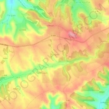
Name: Mourgues topographic map, elevation, terrain.
Average elevation: 253 m
Minimum elevation: 180 m
Maximum elevation: 301 m
Other topographic maps
Click on a map to view its topography, its elevation and its terrain.
Bagat-en-Quercy
France > Occitanie > Lot > Barguelonne-en-Quercy
Bagat-en-Quercy, Barguelonne-en-Quercy, Cahors, Lot, Occitanie, France métropolitaine, 46800, France
Average elevation: 241 m
Saint-Pantaléon
France > Occitanie > Lot > Barguelonne-en-Quercy
Saint-Pantaléon, Barguelonne-en-Quercy, Cahors, Lot, Occitanie, France métropolitaine, 46800, France
Average elevation: 249 m
Les Granges
France > Occitanie > Lot > Barguelonne-en-Quercy > Les Granges
Les Granges, Saint-Daunès, Barguelonne-en-Quercy, Cahors, Lot, Occitanie, France métropolitaine, 46800, France
Average elevation: 211 m
Saint-Daunès
France > Occitanie > Lot > Barguelonne-en-Quercy
Saint-Daunès, Barguelonne-en-Quercy, Cahors, Lot, Occitanie, France métropolitaine, 46800, France
Average elevation: 219 m