
Ardrossan topographic map
Interactive map
Click on the map to display elevation.
About this map
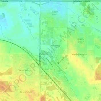
Name: Ardrossan topographic map, elevation, terrain.
Location: Ardrossan, Strathcona County, Alberta, T8E 2A2, Canada (53.54849 -113.14785 53.56491 -113.13563)
Average elevation: 710 m
Minimum elevation: 695 m
Maximum elevation: 727 m
Other topographic maps
Click on a map to view its topography, its elevation and its terrain.
Hamlet of Antler Lake
Canada > Alberta > Strathcona County
Hamlet of Antler Lake, Strathcona County, Alberta, Canada
Average elevation: 745 m
Hastings Lake
Canada > Alberta > Strathcona County
Hastings Lake, Strathcona County, Alberta, Canada
Average elevation: 744 m
Hamlet of Josephburg
Canada > Alberta > Strathcona County > Hamlet of Josephburg
Hamlet of Josephburg, Strathcona County, Alberta, T8L 4B8, Canada
Average elevation: 639 m
Cooking Lake
Canada > Alberta > Strathcona County
Cooking Lake, Strathcona County, Alberta, Canada
Average elevation: 745 m