
Baumholder topographic map
Interactive map
Click on the map to display elevation.
About this map
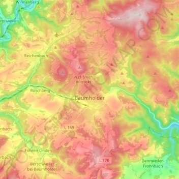
Name: Baumholder topographic map, elevation, terrain.
Average elevation: 451 m
Minimum elevation: 258 m
Maximum elevation: 609 m
Other topographic maps
Click on a map to view its topography, its elevation and its terrain.
Mittelreidenbach
Germany > Rhineland-Palatinate > Landkreis Birkenfeld
Mittelreidenbach, Herrstein-Rhaunen, Landkreis Birkenfeld, Rhineland-Palatinate, Germany
Average elevation: 340 m
Idar-Oberstein
Germany > Rhineland-Palatinate > Landkreis Birkenfeld
Idar-Oberstein, Landkreis Birkenfeld, Rhineland-Palatinate, 55743, Germany
Average elevation: 406 m
Hallenbad Idar-Oberstein
Germany > Rhineland-Palatinate > Landkreis Birkenfeld > Idar-Oberstein
Hallenbad Idar-Oberstein, 213, Hauptstraße, Idar, Idar-Oberstein, Landkreis Birkenfeld, Rhineland-Palatinate, 55743, Germany
Average elevation: 343 m
Heimbach
Germany > Rhineland-Palatinate > Landkreis Birkenfeld
Heimbach, Baumholder, Landkreis Birkenfeld, Rhineland-Palatinate, Germany
Average elevation: 412 m
Gollenberg
Germany > Rhineland-Palatinate > Landkreis Birkenfeld
Gollenberg, Birkenfeld, Landkreis Birkenfeld, Rhineland-Palatinate, Germany
Average elevation: 466 m