
Gundlupet topographic map
Interactive map
Click on the map to display elevation.
About this map
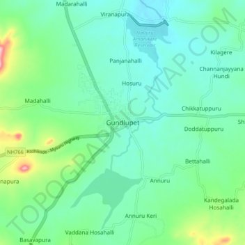
Name: Gundlupet topographic map, elevation, terrain.
Average elevation: 807 m
Minimum elevation: 763 m
Maximum elevation: 956 m
Gundlupet is located at 11°48′N 76°41′E / 11.8°N 76.68°E / 11.8; 76.68.[2] It has an average elevation of 816 metres (2,677 feet).[citation needed]
Other topographic maps
Click on a map to view its topography, its elevation and its terrain.
Bandipur National Park/Tiger Reserve
India > Karnataka > Gundlupet taluk
Bandipur National Park/Tiger Reserve, Gundlupet taluk, Chamarajanagar District, Karnataka, India
Average elevation: 860 m
Hasaguli
India > Karnataka > Gundlupet taluk
Hasaguli, Gundlupet taluk, Chamarajanagar District, Karnataka, 571109, India
Average elevation: 798 m
Moyar
India > Karnataka > Gundlupet taluk
Moyar, Gundlupet taluk, Chamarajanagar district, Karnataka, India
Average elevation: 1,064 m