
温泉镇 topographic map
Interactive map
Click on the map to display elevation.
About this map
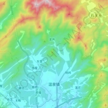
Name: 温泉镇 topographic map, elevation, terrain.
Location: 温泉镇, 岳西县, 安庆市, 安徽省, 中国 (30.87118 116.27034 30.97890 116.39284)
Average elevation: 672 m
Minimum elevation: 373 m
Maximum elevation: 1,547 m
Other topographic maps
Click on a map to view its topography, its elevation and its terrain.