
Thank you for supporting this site ❤️
Make a donation
Make a donation
Mendota Heights topographic map
Click on the map to display elevation.
Thank you for supporting this site ❤️
Make a donation
Make a donation
About this map
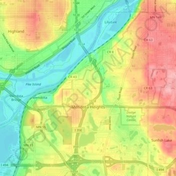
Name: Mendota Heights topographic map, elevation, terrain.
Average elevation: 265 m
Minimum elevation: 209 m
Maximum elevation: 327 m
Thank you for supporting this site ❤️
Make a donation
Make a donation
Other topographic maps
Click on a map to view its topography, its elevation and its terrain.
Burnsville
United States > Minnesota > Dakota County > Burnsville > Burnsville
Average elevation: 275 m
Thank you for supporting this site ❤️
Make a donation
Make a donation
Farmington
United States > Minnesota > Dakota County > Farmington > Farmington
Average elevation: 280 m
Thank you for supporting this site ❤️
Make a donation
Make a donation