
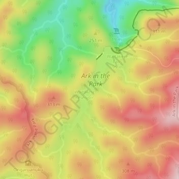
Waitakere Reservoir topographic map
Interactive map
Click on the map to display elevation.
About this map
Name: Waitakere Reservoir topographic map, elevation, terrain.
Average elevation: 237 m
Minimum elevation: 72 m
Maximum elevation: 371 m
Other topographic maps
Click on a map to view its topography, its elevation and its terrain.
Karekare
New Zealand > Auckland > Waitakere Ranges
Karekare, Waitākere Ranges, Auckland, New Zealand
Average elevation: 112 m
Bethells Beach
New Zealand > Auckland > Waitakere Ranges > Te Henga / Bethells Beach
Bethells Beach, Te Henga / Bethells Beach, Waitākere Ranges, Auckland, New Zealand
Average elevation: 33 m
Waiatarua
New Zealand > Auckland > Waitakere Ranges
Waiatarua, Waitākere Ranges, Auckland, New Zealand
Average elevation: 216 m
Mount Atkinson
New Zealand > Auckland > Waitakere Ranges
Mount Atkinson, Waitākere Ranges, Auckland, 0604, New Zealand
Average elevation: 77 m
Piha
New Zealand > Auckland > Waitakere Ranges
Piha, Waitakere Ranges, Auckland, New Zealand
Average elevation: 75 m
Waitākere Stream
New Zealand > Auckland > Waitakere Ranges
Waitākere Stream, Waitakere Ranges, Auckland, New Zealand
Average elevation: 270 m
Kumeu River
New Zealand > Auckland > Waitakere Ranges
Kumeu River, Waitakere Ranges, Auckland, 0810, New Zealand
Average elevation: 63 m
Bethells Beach
New Zealand > Auckland > Waitakere Ranges > Bethells Beach
Bethells Beach, Waitakere Ranges, Auckland, New Zealand
Average elevation: 57 m
Little Huia
New Zealand > Auckland > Waitakere Ranges > Little Huia
Little Huia, Waitakere Ranges, Auckland, New Zealand
Average elevation: 87 m
Maori Stream
New Zealand > Auckland > Waitakere Ranges
Maori Stream, Waitakere Ranges, Auckland, New Zealand
Average elevation: 206 m
Lake Wainamu
New Zealand > Auckland > Waitakere Ranges
Lake Wainamu, Lake Wainamu Track, North Piha, Waitakere Ranges, Auckland, New Zealand
Average elevation: 103 m
Lower Nihotupu Reservoir
New Zealand > Auckland > Waitakere Ranges
Lower Nihotupu Reservoir, Huia Road, Parau, Waitakere Ranges, Auckland, 0604, New Zealand
Average elevation: 86 m
Lake Waiataru
New Zealand > Auckland > Waitakere Ranges
Lake Waiataru, Tiamana Creek Road, North Piha, Waitakere Ranges, Auckland, New Zealand
Average elevation: 65 m
Whatipu Beach
New Zealand > Auckland > Waitakere Ranges
Whatipu Beach, Pararaha Valley Track, Waitakere Ranges, Auckland, New Zealand
Average elevation: 43 m
Upper Huia Reservoir
New Zealand > Auckland > Waitakere Ranges
Upper Huia Reservoir, Upper Huia Dam Track, Waitakere Ranges, Auckland, New Zealand
Average elevation: 248 m
Upper Nihotupu Reservoir
New Zealand > Auckland > Waitakere Ranges
Upper Nihotupu Reservoir, Christies Track, Waitakere Ranges, Auckland, New Zealand
Average elevation: 264 m
Lake Kawaupaka
New Zealand > Auckland > Waitakere Ranges
Lake Kawaupaka, Tiamana Creek Road, North Piha, Waitakere Ranges, Auckland, New Zealand
Average elevation: 85 m
Hikurangi
New Zealand > Auckland > Waitakere Ranges
Hikurangi, Waitakere Ranges, Auckland, New Zealand
Average elevation: 82 m