
El Aguacate topographic map
Interactive map
Click on the map to display elevation.
About this map
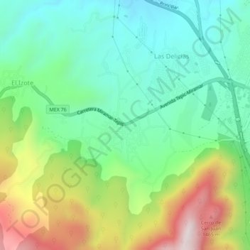
Name: El Aguacate topographic map, elevation, terrain.
Location: El Aguacate, Municipio de Tepic, Nayarit, 63507, México (21.49563 -104.96431 21.53563 -104.92431)
Average elevation: 1,088 m
Minimum elevation: 839 m
Maximum elevation: 1,585 m
Other topographic maps
Click on a map to view its topography, its elevation and its terrain.
El Aguacate
México > Nayarit > El Aguacate
El Aguacate, Ixtlán del Río, Nayarit, México
Average elevation: 1,094 m
Sierra de San Juan
México > Nayarit > El Aguacate
Sierra de San Juan, Retorno, El Aguacate, Municipio de Tepic, Nayarit, 63115, México
Average elevation: 1,232 m