
Thank you for supporting this site ❤️
Make a donation
Make a donation
Yongzhou topographic map
Click on the map to display elevation.
Thank you for supporting this site ❤️
Make a donation
Make a donation
About this map
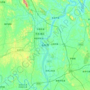
Name: Yongzhou topographic map, elevation, terrain.
Location: Yongzhou, Lengshuitan District, Yongzhou, Hunan, China (26.26357 111.44815 26.58357 111.76815)
Average elevation: 137 m
Minimum elevation: 76 m
Maximum elevation: 413 m
Thank you for supporting this site ❤️
Make a donation
Make a donation
Other topographic maps
Click on a map to view its topography, its elevation and its terrain.
Changsha County
Changsha County is located in the northern part of the Changsha-Hengyang Hilly Basin (Chinese: 长衡丘陵盆地). It is located at the southern end of the Mufu Mountains, Lianyun Mountains (Chinese: 连云山) and the branches of Dalong Mountain (Chinese: 大龙山), and the northern edge of the Zhuzhou…
Average elevation: 101 m
Thank you for supporting this site ❤️
Make a donation
Make a donation
Thank you for supporting this site ❤️
Make a donation
Make a donation
Zhijiang Dong Autonomous County
China > Hunan > Zhijiang Dong Autonomous County
Average elevation: 419 m