
Ouled Rabah topographic map
Interactive map
Click on the map to display elevation.
About this map
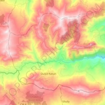
Name: Ouled Rabah topographic map, elevation, terrain.
Location: Ouled Rabah, Daïra Sidi Maarouf, Jijel, Algérie (36.57928 6.11427 36.66434 6.25461)
Average elevation: 830 m
Minimum elevation: 126 m
Maximum elevation: 1,334 m
Other topographic maps
Click on a map to view its topography, its elevation and its terrain.
Sidi Maarouf
Algérie > Jijel > Daïra Sidi Maarouf > Sidi Maarouf
Sidi Maarouf, Daïra Sidi Maarouf, Jijel, 18018, Algérie
Average elevation: 524 m