
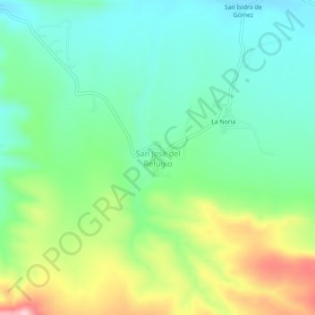
San José del Refugio topographic map
Interactive map
Click on the map to display elevation.
About this map
Name: San José del Refugio topographic map, elevation, terrain.
Location: San José del Refugio, General Cepeda, Coahuila, México (25.27465 -101.41972 25.31465 -101.37972)
Average elevation: 1,730 m
Minimum elevation: 1,649 m
Maximum elevation: 1,901 m
Other topographic maps
Click on a map to view its topography, its elevation and its terrain.
General Cepeda
México > Coahuila > General Cepeda
General Cepeda, Coahuila, México
Average elevation: 1,486 m
Rincón Colorado
México > Coahuila > General Cepeda
Rincón Colorado, General Cepeda, Coahuila, 25970, México
Average elevation: 1,280 m