
Wasmuel topographic map
Interactive map
Click on the map to display elevation.
About this map
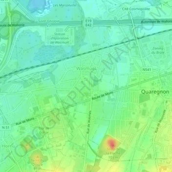
Name: Wasmuel topographic map, elevation, terrain.
Location: Wasmuel, Quaregnon, Mons, Hainaut, Wallonie, 7390, Belgique (50.43340 3.82848 50.45252 3.85427)
Average elevation: 31 m
Minimum elevation: 16 m
Maximum elevation: 61 m
Other topographic maps
Click on a map to view its topography, its elevation and its terrain.
Les Six Chemins
Belgique > Hainaut > Mons > Quaregnon
Les Six Chemins, Quaregnon, Mons, Hainaut, Wallonie, 7390, Belgique
Average elevation: 68 m