
Make a donation
Wales topographic map
Click on the map to display elevation.
Make a donation
Wales
Wales is predominantly mountainous, with its terrain shaped by ancient geological processes and glaciation. In the north, Snowdonia (Eryri) boasts the country's highest peaks, including Snowdon (Yr Wyddfa) at 1,085 meters (3,560 feet). Central Wales is characterized by the Cambrian Mountains, featuring rounded, undulating landscapes covered in moorland and rough grassland. The southern region is home to the Brecon Beacons (Bannau Brycheiniog), with notable summits like Pen y Fan at 886 meters (2,907 feet). Beyond its uplands, Wales offers diverse lowland areas, including the north coastal plain, the island of Anglesey, parts of the Llŷn Peninsula, narrow coastal strips along Cardigan Bay, much of Pembrokeshire and southern Carmarthenshire, the Gower Peninsula, and the Vale of Glamorgan. The country's extensive coastline, stretching approximately 1,370 miles (2,200 kilometers), features a mix of rugged cliffs and sandy beaches, further enriching its varied topography.
Make a donation
About this map
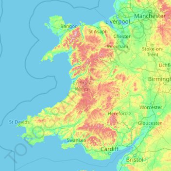
Name: Wales topographic map, elevation, terrain.
Location: Wales, United Kingdom (51.22903 -5.80773 53.63500 -2.64986)
Average elevation: 99 m
Minimum elevation: 0 m
Maximum elevation: 1,001 m
Make a donation
Other topographic maps
Click on a map to view its topography, its elevation and its terrain.
Make a donation
Make a donation
Wakebridge
United Kingdom > England > Derbyshire > Amber Valley > Crich Carr > Wakebridge
Average elevation: 181 m
Make a donation