
Mankato topographic map
Interactive map
Click on the map to display elevation.
About this map
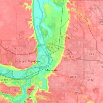
Name: Mankato topographic map, elevation, terrain.
Average elevation: 285 m
Minimum elevation: 226 m
Maximum elevation: 314 m
Other topographic maps
Click on a map to view its topography, its elevation and its terrain.
Mankato
États-Unis d'Amérique > Minnesota > Blue Earth County > Mankato > Mankato
Mankato, Blue Earth County, Minnesota, 56001, États-Unis d'Amérique
Average elevation: 298 m
Pemberton
États-Unis d'Amérique > Minnesota > Blue Earth County
Pemberton, Blue Earth County, Minnesota, États-Unis d'Amérique
Average elevation: 316 m