
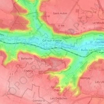
Gif-sur-Yvette topographic map
Interactive map
Click on the map to display elevation.
About this map
Name: Gif-sur-Yvette topographic map, elevation, terrain.
Average elevation: 135 m
Minimum elevation: 57 m
Maximum elevation: 175 m
Other topographic maps
Click on a map to view its topography, its elevation and its terrain.
Les Fossées
Frankrijk > Île-de-France > Essonne > Villeconin > Fourchainville
Les Fossées, Fourchainville, Villeconin, Étampes, Essonne, Île-de-France, Metropolitaans Frankrijk, 91580, Frankrijk
Average elevation: 132 m
Palaiseau
Frankrijk > Île-de-France > Essonne
Palaiseau, Essonne, Île-de-France, Metropolitaans Frankrijk, 91120, Frankrijk
Average elevation: 95 m
Ventoux
Frankrijk > Île-de-France > Essonne > Les Ulis
Ventoux, Les Ulis, Palaiseau, Essonne, Île-de-France, Metropolitaans Frankrijk, 91940, Frankrijk
Average elevation: 154 m
Les Molières
Frankrijk > Île-de-France > Essonne
Les Molières, Palaiseau, Essonne, Île-de-France, Metropolitaans Frankrijk, 91470, Frankrijk
Average elevation: 167 m