
Albertville topographic map
Interactive map
Click on the map to display elevation.
About this map
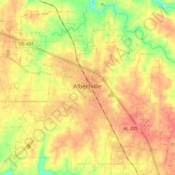
Name: Albertville topographic map, elevation, terrain.
Location: Albertville, Marshall County, Alabama, 35950, United States (34.21637 -86.27448 34.31681 -86.14596)
Average elevation: 309 m
Minimum elevation: 254 m
Maximum elevation: 356 m
The city sits at an elevation of 1,060 feet (320 m) atop Sand Mountain, a plateau that in this area is about 15 miles (24 km) wide. The Tennessee Valley Divide passes through the southern part of the city. The majority of the city drains north to Short Creek, a tributary of the Tennessee River, while the southern part drains to Slab Creek, a west-flowing tributary of the Locust Fork of the Black Warrior River. The current slogan of Albertville is "The Heart of Sand Mountain", which can be seen on the welcome sign coming into the city.
Other topographic maps
Click on a map to view its topography, its elevation and its terrain.
Grassy
United States > Alabama > Marshall County
Grassy, Marshall County, Alabama, United States
Average elevation: 309 m
Arab
United States > Alabama > Marshall County
Arab, Marshall County, Alabama, 35016, United States
Average elevation: 314 m