
Port Townsend topographic map
Interactive map
Click on the map to display elevation.
About this map
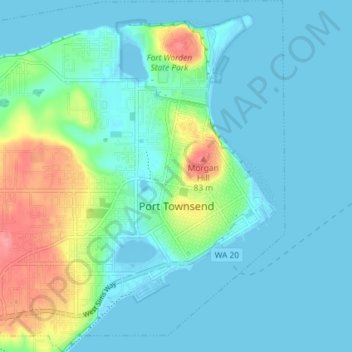
Name: Port Townsend topographic map, elevation, terrain.
Location: Port Townsend, Jefferson County, Washington, United States (48.09772 -122.81632 48.14630 -122.74714)
Average elevation: 19 m
Minimum elevation: -7 m
Maximum elevation: 90 m
Other topographic maps
Click on a map to view its topography, its elevation and its terrain.
Olympic National Park
United States > Washington > Jefferson County
Olympic National Park, Jefferson County, Washington, United States
Average elevation: 412 m
Quimper Peninsula
United States > Washington > Jefferson County
Quimper Peninsula, Jefferson County, Washington, 98368, United States
Average elevation: 69 m
Queets
United States > Washington > Jefferson County
Queets, Jefferson County, Washington, United States
Average elevation: 36 m
Marrowstone
United States > Washington > Jefferson County > Marrowstone
Marrowstone, Jefferson County, Washington, 98358, United States
Average elevation: 11 m
Admiralty Inlet
United States > Washington > Jefferson County > Port Townsend
Admiralty Inlet, Port Townsend, Jefferson County, Washington, United States
Average elevation: 34 m
Chimacum
United States > Washington > Jefferson County
Chimacum, Jefferson County, Washington, 98339, United States
Average elevation: 59 m
Port Ludlow
United States > Washington > Jefferson County > Port Ludlow
Port Ludlow, Jefferson County, Washington, 98365, United States
Average elevation: 64 m
Upper Hoh
United States > Washington > Jefferson County
Upper Hoh, Jefferson County, Washington, United States
Average elevation: 161 m
Port Hadlock
United States > Washington > Jefferson County
Port Hadlock, Jefferson County, Washington, 98339, United States
Average elevation: 31 m
Lackawanna Beach
United States > Washington > Jefferson County
Lackawanna Beach, Jefferson County, Washington, 98320, United States
Average elevation: 18 m
Brinnon
United States > Washington > Jefferson County
Brinnon, Jefferson County, Washington, 98320, United States
Average elevation: 204 m
Port Townsend
United States > Washington > Jefferson County > Port Townsend
Port Townsend, Jefferson County, Washington, United States
Average elevation: 31 m
Mount Townsend
United States > Washington > Jefferson County
Mount Townsend, Jefferson County, Washington, United States
Average elevation: 1,518 m
Port Townsend
United States > Washington > Jefferson County > Port Townsend > Port Townsend
Port Townsend, Jefferson County, Washington, United States
Average elevation: 18 m
Nordland
United States > Washington > Jefferson County > Nordland
Nordland, Jefferson County, Washington, 98339, United States
Average elevation: 11 m
Mount Olympus
United States > Washington > Jefferson County
Mount Olympus, Jefferson County, Washington, United States
Average elevation: 1,934 m
Quilcene
United States > Washington > Jefferson County
Quilcene, Jefferson County, Washington, United States
Average elevation: 116 m
Tukey
United States > Washington > Jefferson County
Tukey, Jefferson County, Washington, United States
Average elevation: 34 m