
Kelleytown topographic map
Interactive map
Click on the map to display elevation.
About this map
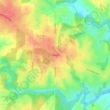
Name: Kelleytown topographic map, elevation, terrain.
Location: Kelleytown, Henry County, Georgia, United States (33.51733 -84.10908 33.55733 -84.06908)
Average elevation: 220 m
Minimum elevation: 182 m
Maximum elevation: 259 m
Other topographic maps
Click on a map to view its topography, its elevation and its terrain.
Flippen
United States > Georgia > Henry County
Flippen, Henry County, Georgia, 30253, United States
Average elevation: 252 m
Peeksville
United States > Georgia > Henry County
Peeksville, Henry County, Georgia, United States
Average elevation: 197 m
Blacksville
United States > Georgia > Henry County
Blacksville, Henry County, Georgia, United States
Average elevation: 263 m
Whitehouse
United States > Georgia > Henry County
Whitehouse, Henry County, Georgia, United States
Average elevation: 230 m
Ola
United States > Georgia > Henry County
Ola, Henry County, Georgia, United States
Average elevation: 230 m
McDonough
United States > Georgia > Henry County
McDonough, Henry County, Georgia, 30253, United States
Average elevation: 249 m
Hiram Cook Lake
United States > Georgia > Henry County
Hiram Cook Lake, Henry County, Georgia, United States
Average elevation: 248 m
Weems Lake
United States > Georgia > Henry County
Weems Lake, Henry County, Georgia, United States
Average elevation: 245 m
Locust Grove
United States > Georgia > Henry County
Locust Grove, Henry County, Georgia, 30248, United States
Average elevation: 230 m
Hampton
United States > Georgia > Henry County
Hampton, Henry County, Georgia, United States
Average elevation: 258 m
McDonough
United States > Georgia > Henry County > McDonough
McDonough, Henry County, Georgia, 30253, United States
Average elevation: 248 m
Stockbridge
United States > Georgia > Henry County
Stockbridge, Henry County, Georgia, United States
Average elevation: 243 m