
Lesparat topographic map
Interactive map
Click on the map to display elevation.
About this map
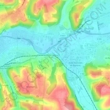
Name: Lesparat topographic map, elevation, terrain.
Average elevation: 130 m
Minimum elevation: 85 m
Maximum elevation: 210 m
Other topographic maps
Click on a map to view its topography, its elevation and its terrain.
Boulazac
France > Nouvelle-Aquitaine > Dordogne > Boulazac Isle Manoire
Boulazac, Boulazac Isle Manoire, Périgueux, Dordogne, Nouvelle-Aquitaine, France métropolitaine, 24750, France
Average elevation: 141 m
Les Rebières
France > Nouvelle-Aquitaine > Dordogne > Boulazac Isle Manoire > Les Rebières
Les Rebières, Boulazac, Boulazac Isle Manoire, Périgueux, Dordogne, Nouvelle-Aquitaine, France métropolitaine, 24750, France
Average elevation: 133 m
La Croix Bertrix
France > Nouvelle-Aquitaine > Dordogne > Boulazac Isle Manoire
La Croix Bertrix, Boulazac, Boulazac Isle Manoire, Périgueux, Dordogne, Nouvelle-Aquitaine, France métropolitaine, 24750, France
Average elevation: 136 m