
Mouthcard topographic map
Interactive map
Click on the map to display elevation.
About this map
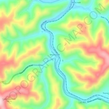
Name: Mouthcard topographic map, elevation, terrain.
Location: Mouthcard, Pike County, Kentucky, 41548, United States (37.36427 -82.27514 37.40427 -82.23514)
Average elevation: 393 m
Minimum elevation: 240 m
Maximum elevation: 615 m
Other topographic maps
Click on a map to view its topography, its elevation and its terrain.
Elkhorn City
United States > Kentucky > Pike County
Elkhorn City, Pike County, Kentucky, United States
Average elevation: 364 m
Pikeville
United States > Kentucky > Pike County
Pikeville, Pike County, Kentucky, 41501, United States
Average elevation: 338 m
Jonancy
United States > Kentucky > Pike County
Jonancy, Pike County, Kentucky, 41538, United States
Average elevation: 399 m
McAndrews
United States > Kentucky > Pike County
McAndrews, Pike County, Kentucky, 41567, United States
Average elevation: 374 m
Pleasant Valley
United States > Kentucky > Pike County > Pikeville
Pleasant Valley, Pikeville, Pike County, Kentucky, 41501, United States
Average elevation: 315 m
Penny
United States > Kentucky > Pike County
Penny, Pike County, Kentucky, 41560, United States
Average elevation: 378 m
Toler
United States > Kentucky > Pike County
Toler, Pike County, Kentucky, 25661, United States
Average elevation: 320 m
Phyllis
United States > Kentucky > Pike County
Phyllis, Pike County, Kentucky, 41554, United States
Average elevation: 406 m
Pikeville
United States > Kentucky > Pike County > Pikeville > Pikeville
Pikeville, Pike County, Kentucky, 41501, United States
Average elevation: 312 m
Turkey Creek
United States > Kentucky > Pike County > Turkey Creek
Turkey Creek, Pike County, Kentucky, 41514, United States
Average elevation: 312 m
Lick Creek
United States > Kentucky > Pike County
Lick Creek, Pike County, Kentucky, 41540, United States
Average elevation: 430 m