
Plattkofel topographic map
Interactive map
Click on the map to display elevation.
About this map
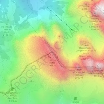
Name: Plattkofel topographic map, elevation, terrain.
Average elevation: 2,395 m
Minimum elevation: 1,831 m
Maximum elevation: 3,160 m
Der Plattkofel ist der westlichste Berg der Langkofelgruppe zwischen Gröden in Südtirol und dem Fassatal im Trentino. Während die namengebende Westflanke recht ebenmäßig und verhältnismäßig flach zum Gipfelgrat ansteigt, bricht die Ostflanke unvermittelt steil zum Plattkofelkar ab. Der grob in Nordwest-Südost-Richtung verlaufende Gipfelgrat weist drei Gipfelpunkte auf. Der touristisch bedeutendste ist der über markierte Steige erreichbare Mittelgipfel (2958 m) mit einem Gipfelkreuz. Der höchste Punkt des Bergs findet sich jedoch am Südostgipfel mit einer Höhe von 2964 m, während der Nordwestgipfel eine Höhe von 2954 m aufweist.
Other topographic maps
Click on a map to view its topography, its elevation and its terrain.
Langkofel
Italien > Trentino-Südtirol > Bozen > St. Christina in Gröden
Langkofel, St. Christina in Gröden, Salten-Schlern, Bozen, Trentino-Südtirol, 39048, Italien
Average elevation: 2,320 m
Langkofel
Italien > Trentino-Südtirol > Bozen > St. Christina in Gröden
Langkofel, St. Christina in Gröden, Salten-Schlern, Bozen, Trentino-Südtirol, 39048, Italien
Average elevation: 2,322 m