
Corinth topographic map
Interactive map
Click on the map to display elevation.
About this map
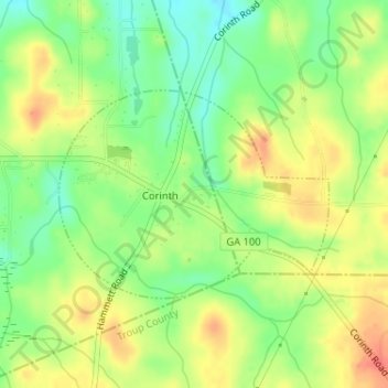
Name: Corinth topographic map, elevation, terrain.
Location: Corinth, Heard County, Georgia, United States (33.22296 -84.95390 33.23743 -84.93146)
Average elevation: 233 m
Minimum elevation: 207 m
Maximum elevation: 258 m
Other topographic maps
Click on a map to view its topography, its elevation and its terrain.
Houston
United States > Georgia > Heard County
Houston, Heard County, Georgia, 30219, United States
Average elevation: 229 m
Glenn
United States > Georgia > Heard County
Glenn, Heard County, Georgia, United States
Average elevation: 239 m
Cooksville
United States > Georgia > Heard County
Cooksville, Heard County, Georgia, United States
Average elevation: 212 m
Glenloch
United States > Georgia > Heard County
Glenloch, Heard County, Georgia, United States
Average elevation: 289 m
Roosterville
United States > Georgia > Heard County
Roosterville, Heard County, Georgia, 30170, United States
Average elevation: 302 m
Viola
United States > Georgia > Heard County
Viola, Heard County, Georgia, United States
Average elevation: 237 m
Owensbyville
United States > Georgia > Heard County
Owensbyville, Heard County, Georgia, United States
Average elevation: 214 m
Centralhatchee
United States > Georgia > Heard County
Centralhatchee, Heard County, Georgia, United States
Average elevation: 252 m
Texas
United States > Georgia > Heard County
Texas, Heard County, Georgia, United States
Average elevation: 258 m
Yellow Dirt
United States > Georgia > Heard County
Yellow Dirt, Heard County, Georgia, United States
Average elevation: 237 m
Franklin
United States > Georgia > Heard County
Franklin, Heard County, Georgia, United States
Average elevation: 223 m
Ephesus
United States > Georgia > Heard County
Ephesus, Heard County, Georgia, United States
Average elevation: 360 m