
Bragg Creek topographic map
Interactive map
Click on the map to display elevation.
About this map
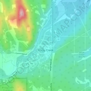
Name: Bragg Creek topographic map, elevation, terrain.
Location: Bragg Creek, Rocky View County, Alberta, Canada (50.94132 -114.58357 50.96424 -114.55960)
Average elevation: 1,326 m
Minimum elevation: 1,279 m
Maximum elevation: 1,477 m
Other topographic maps
Click on a map to view its topography, its elevation and its terrain.
Langdon
Canada > Alberta > Rocky View County
Langdon, Rocky View County, Alberta, Canada
Average elevation: 1,007 m
Bragg Creek
Canada > Alberta > Rocky View County
Bragg Creek, Rocky View County, Alberta, T0L 0K0, Canada
Average elevation: 1,332 m
Jumping Pound
Canada > Alberta > Rocky View County
Jumping Pound, Rocky View County, Alberta, Canada
Average elevation: 1,253 m
Madden
Canada > Alberta > Rocky View County
Madden, Rocky View County, Alberta, Canada
Average elevation: 1,151 m
Balzac
Canada > Alberta > Rocky View County
Balzac, Rocky View County, Alberta, T0M 0E0, Canada
Average elevation: 1,088 m