
Bucksnort topographic map
Interactive map
Click on the map to display elevation.
About this map
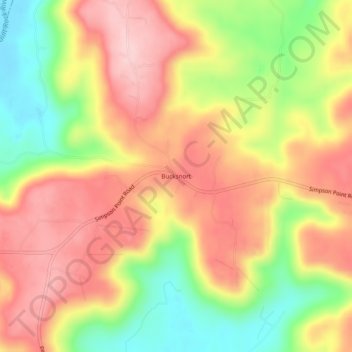
Name: Bucksnort topographic map, elevation, terrain.
Location: Bucksnort, Marshall County, Alabama, 35747, United States (34.48314 -86.32387 34.52314 -86.28387)
Average elevation: 289 m
Minimum elevation: 170 m
Maximum elevation: 382 m
Other topographic maps
Click on a map to view its topography, its elevation and its terrain.
Guntersville
United States > Alabama > Marshall County
Guntersville, Marshall County, Alabama, 35976, United States
Average elevation: 242 m
Needmore
United States > Alabama > Marshall County
Needmore, Marshall County, Alabama, United States
Average elevation: 294 m
Albertville
United States > Alabama > Marshall County
Albertville, Marshall County, Alabama, 35950, United States
Average elevation: 309 m
Union Grove
United States > Alabama > Marshall County > Union Grove
Union Grove, Marshall County, Alabama, United States
Average elevation: 300 m
Lake Guntersville State Park
United States > Alabama > Marshall County > Guntersville
Lake Guntersville State Park, Guntersville, Marshall County, Alabama, United States
Average elevation: 242 m
Grant
United States > Alabama > Marshall County
Grant, Marshall County, Alabama, 35847, United States
Average elevation: 300 m
Shoal Creek
United States > Alabama > Marshall County > Arab
Shoal Creek, Arab, Marshall County, Alabama, 35016, United States
Average elevation: 327 m
Lindsay Lane
United States > Alabama > Marshall County > Guntersville
Lindsay Lane, Guntersville, Marshall County, Alabama, 35976, United States
Average elevation: 249 m
Union Grove
United States > Alabama > Marshall County
Union Grove, Marshall County, Alabama, United States
Average elevation: 299 m
Boaz
United States > Alabama > Marshall County
Boaz, Marshall County, Alabama, 35957, United States
Average elevation: 320 m
Wyeth City
United States > Alabama > Marshall County > Guntersville > Wyeth City
Wyeth City, Guntersville, Marshall County, Alabama, 35976, United States
Average elevation: 230 m
Guntersville
United States > Alabama > Marshall County > Guntersville
Guntersville, Marshall County, Alabama, 35976, United States
Average elevation: 208 m
Bob Mountain
United States > Alabama > Marshall County
Bob Mountain, Marshall County, Alabama, United States
Average elevation: 206 m
Arab
United States > Alabama > Marshall County
Arab, Marshall County, Alabama, 35016, United States
Average elevation: 314 m