
Cappel topographic map
Interactive map
Click on the map to display elevation.
About this map
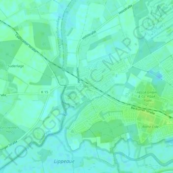
Name: Cappel topographic map, elevation, terrain.
Location: Cappel, Lippstadt, Kreis Soest, Nordrhein-Westfalen, Deutschland (51.67099 8.29292 51.69620 8.31528)
Average elevation: 75 m
Minimum elevation: 71 m
Maximum elevation: 81 m
Other topographic maps
Click on a map to view its topography, its elevation and its terrain.
Dedinghausen
Deutschland > Nordrhein-Westfalen > Kreis Soest > Lippstadt
Dedinghausen, Lippstadt, Kreis Soest, Nordrhein-Westfalen, Deutschland
Average elevation: 89 m
Hellinghausen
Deutschland > Nordrhein-Westfalen > Kreis Soest > Lippstadt
Hellinghausen, Herringhausen, Lippstadt, Kreis Soest, Nordrhein-Westfalen, Deutschland
Average elevation: 75 m
Lipperode
Deutschland > Nordrhein-Westfalen > Kreis Soest > Lippstadt
Lipperode, Lippstadt, Kreis Soest, Nordrhein-Westfalen, Deutschland
Average elevation: 78 m
Eickelborn
Deutschland > Nordrhein-Westfalen > Kreis Soest > Lippstadt
Eickelborn, Lippstadt, Kreis Soest, Nordrhein-Westfalen, Deutschland
Average elevation: 79 m
Hörste
Deutschland > Nordrhein-Westfalen > Kreis Soest > Lippstadt > Hörste
Hörste, Lippstadt, Kreis Soest, Nordrhein-Westfalen, 59558, Deutschland
Average elevation: 84 m
Lipperode
Deutschland > Nordrhein-Westfalen > Kreis Soest > Lippstadt
Lipperode, Lippstadt, Kreis Soest, Nordrhein-Westfalen, 59558, Deutschland
Average elevation: 78 m
Overhagen
Deutschland > Nordrhein-Westfalen > Kreis Soest > Lippstadt
Overhagen, Lippstadt, Kreis Soest, Nordrhein-Westfalen, Deutschland
Average elevation: 79 m