
Pfaffenkopf topographic map
Interactive map
Click on the map to display elevation.
About this map
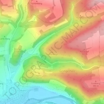
Name: Pfaffenkopf topographic map, elevation, terrain.
Location: Pfaffenkopf, Treffurt, Wartburgkreis, Thüringen, Deutschland (51.12729 10.28299 51.12739 10.28309)
Average elevation: 297 m
Minimum elevation: 177 m
Maximum elevation: 411 m
Other topographic maps
Click on a map to view its topography, its elevation and its terrain.
Observation Point India
Deutschland > Thüringen > Wartburgkreis > Treffurt > Ifta
Observation Point India, Kolonnenweg, Ifta, Treffurt, Wartburgkreis, Thüringen, 99830, Deutschland
Average elevation: 333 m
Hüneburg
Deutschland > Thüringen > Wartburgkreis > Treffurt
Hüneburg, Treffurt, Wartburgkreis, Thüringen, 99830, Deutschland
Average elevation: 341 m