
Thank you for supporting this site ❤️
Make a donation
Make a donation
Essen topographic map
Click on the map to display elevation.
Thank you for supporting this site ❤️
Make a donation
Make a donation
Essen
The lowest point can be found in the northern borough of Karnap at 26.5 metres (86.9 ft), the highest point in the borough of Heidhausen at 202.5 metres (664 ft). The average elevation is 116 metres (381 ft).
Thank you for supporting this site ❤️
Make a donation
Make a donation
About this map
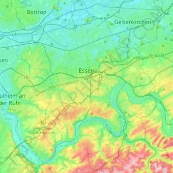
Name: Essen topographic map, elevation, terrain.
Location: Essen, North Rhine-Westphalia, Germany (51.34757 6.89434 51.53423 7.13765)
Average elevation: 86 m
Minimum elevation: 27 m
Maximum elevation: 254 m
Thank you for supporting this site ❤️
Make a donation
Make a donation
Other topographic maps
Click on a map to view its topography, its elevation and its terrain.