
Springdale topographic map
Interactive map
Click on the map to display elevation.
About this map
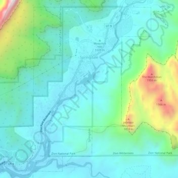
Name: Springdale topographic map, elevation, terrain.
Average elevation: 1,354 m
Minimum elevation: 1,143 m
Maximum elevation: 2,181 m
Other topographic maps
Click on a map to view its topography, its elevation and its terrain.
Zion National Park
États-Unis d'Amérique > Utah > Washington County
Zion National Park, Washington County, Utah, États-Unis d'Amérique
Average elevation: 1,877 m