
Plœmeur topographic map
Interactive map
Click on the map to display elevation.
About this map
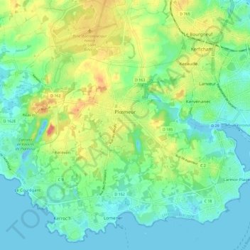
Name: Plœmeur topographic map, elevation, terrain.
Average elevation: 20 m
Minimum elevation: -13 m
Maximum elevation: 62 m
La partie intérieure de la commune est constituée pour l'essentiel d'un plateau qui ne dépasse qu'à peine 50 mètres d'altitude, le terril de la carrière de kaolin de Kergantic étant le sommet le plus visible de loin.
Other topographic maps
Click on a map to view its topography, its elevation and its terrain.
Larmor-Plage
Larmor-Plage, Lorient, Morbihan, Bretagne, France métropolitaine, 56260, France
Average elevation: 6 m
Saint-Gildas-de-Rhuys
Saint-Gildas-de-Rhuys, Vannes, Morbihan, Bretagne, France métropolitaine, 56730, France
Average elevation: 12 m
Le Bois Josselin
France > Bretagne > Morbihan > Ploërmel
Le Bois Josselin, Ploërmel, Pontivy, Morbihan, Bretagne, France métropolitaine, 56800, France
Average elevation: 88 m
Glénac
France > Bretagne > Morbihan > La Gacilly
Glénac, La Gacilly, Vannes, Morbihan, Bretagne, France métropolitaine, 56200, France
Average elevation: 31 m
Kernolivès
France > Bretagne > Morbihan > Saint-Gildas-de-Rhuys
Kernolivès, Saint-Gildas-de-Rhuys, Vannes, Morbihan, Bretagne, France métropolitaine, 56730, France
Average elevation: 18 m
Saint-Tugdual
Saint-Tugdual, Pontivy, Morbihan, Bretagne, France métropolitaine, 56540, France
Average elevation: 202 m
Cotillon
France > Bretagne > Morbihan > Inzinzac-Lochrist
Cotillon, Inzinzac-Lochrist, Lorient, Morbihan, Bretagne, France métropolitaine, 56650, France
Average elevation: 56 m
Korn Er Lann
France > Bretagne > Morbihan > Saint-Aignan
Korn Er Lann, Saint-Aignan, Pontivy, Morbihan, Bretagne, France métropolitaine, 56480, France
Average elevation: 160 m