
Marib Governorate topographic map
Interactive map
Click on the map to display elevation.
About this map
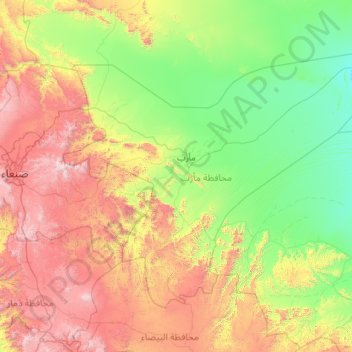
Name: Marib Governorate topographic map, elevation, terrain.
Location: Marib Governorate, Yemen (14.50398 44.52069 16.16188 46.81083)
Average elevation: 1,527 m
Minimum elevation: 856 m
Maximum elevation: 3,319 m
The governorate's climate varies based on elevation. The mountainous and elevated regions, which make up the western half of the governorate, are dominated by a moderate climate with hot summers and relatively cold winters. In the low-lying and plain regions, the climate is hot in the summers and moderate in the winters. The desert regions are characterized by a dry climate: hot in the summers, and cold and dry in the winters.
Other topographic maps
Click on a map to view its topography, its elevation and its terrain.
Al Madinah
Yemen > Ta'izz Governorate > Al Madinah
Al Madinah, Jabal Habashy District, Ta'izz Governorate, Yemen
Average elevation: 1,184 m
Tarim District
Tarim District, Hadramaut Governorate, Yemen
Average elevation: 879 m
Basra
Yemen > Hadramaut Governorate > Basra
Basra, Aryaf al Mukalla District, Hadramaut Governorate, Yemen
Average elevation: 63 m