
Monduli topographic map
Interactive map
Click on the map to display elevation.
About this map
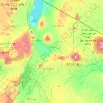
Name: Monduli topographic map, elevation, terrain.
Location: Monduli, Région d'Arusha, Northern Zone, Tanzanie (-4.15051 35.82073 -2.75910 36.65031)
Average elevation: 1,369 m
Minimum elevation: 705 m
Maximum elevation: 4,430 m
Other topographic maps
Click on a map to view its topography, its elevation and its terrain.
Engaruka
Engaruka, Monduli, Région d'Arusha, Northern Zone, Tanzanie
Average elevation: 871 m
Arusha
Arusha, Arusha Municipal, Région d'Arusha, Northern Zone, 23103, Tanzanie
Average elevation: 1,572 m
Usa River
Usa River, Meru, Région d'Arusha, Northern Zone, Tanzanie
Average elevation: 1,197 m
Meru
Meru, Région d'Arusha, Northern Zone, 23316, Tanzanie
Average elevation: 1,342 m
Ngorongoro
Ngorongoro, Région d'Arusha, Northern Zone, Tanzanie
Average elevation: 1,481 m
Ol Doinyo Lengai
Ol Doinyo Lengai, Monduli, Région d'Arusha, Northern Zone, Tanzanie
Average elevation: 2,356 m