
Port de l'Homme topographic map
Interactive map
Click on the map to display elevation.
About this map
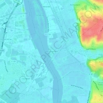
Name: Port de l'Homme topographic map, elevation, terrain.
Average elevation: 11 m
Minimum elevation: -4 m
Maximum elevation: 73 m
Other topographic maps
Click on a map to view its topography, its elevation and its terrain.
Bamboulayre
France > Nouvelle-Aquitaine > Gironde > Latresne
Bamboulayre, Latresne, Bordeaux, Gironde, Nouvelle-Aquitaine, France métropolitaine, 33360, France
Average elevation: 29 m
Lartigot
France > Nouvelle-Aquitaine > Gironde > Latresne
Lartigot, Latresne, Bordeaux, Gironde, Nouvelle-Aquitaine, France métropolitaine, 33360, France
Average elevation: 16 m
Linas
France > Nouvelle-Aquitaine > Gironde > Latresne
Linas, Latresne, Bordeaux, Gironde, Nouvelle-Aquitaine, France métropolitaine, 33360, France
Average elevation: 26 m