
Thank you for supporting this site ❤️
Make a donation
Make a donation
Agua Prieta topographic map
Click on the map to display elevation.
Thank you for supporting this site ❤️
Make a donation
Make a donation
About this map
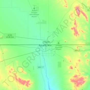
Name: Agua Prieta topographic map, elevation, terrain.
Location: Agua Prieta, Sonora, 84210, Mexico (31.17056 -109.71643 31.49056 -109.39643)
Average elevation: 1,311 m
Minimum elevation: 1,120 m
Maximum elevation: 1,913 m
Thank you for supporting this site ❤️
Make a donation
Make a donation