
Thank you for supporting this site ❤️
Make a donation
Make a donation
Dolores Hidalgo topographic map
Click on the map to display elevation.
Thank you for supporting this site ❤️
Make a donation
Make a donation
Dolores Hidalgo
It is located at 21°10′N 100°56′W / 21.17°N 100.93°W / 21.17; -100.93, at an elevation of about 1,980 meters (6,500 feet) above sea level. In the census of 2005 the city had a population of 54,843, while the municipality had 134,641 inhabitants. The city lies directly in the center of the municipality, which is 1,656 km2 (639 sq mi) in area and includes numerous small outlying communities, the largest of which is Río Laja with a population of 2,211 (2005 census).
Thank you for supporting this site ❤️
Make a donation
Make a donation
About this map
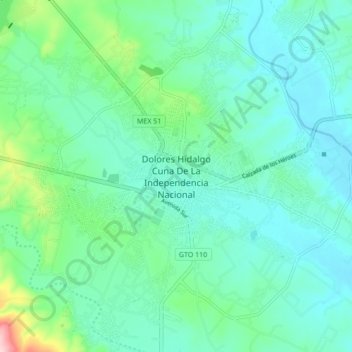
Name: Dolores Hidalgo topographic map, elevation, terrain.
Location: Dolores Hidalgo, Guanajuato, 37800, Mexico (21.11740 -100.97462 21.19740 -100.89462)
Average elevation: 1,938 m
Minimum elevation: 1,893 m
Maximum elevation: 2,124 m
Thank you for supporting this site ❤️
Make a donation
Make a donation