
Thank you for supporting this site ❤️
Make a donation
Make a donation
Linciaux topographic map
Click on the map to display elevation.
Thank you for supporting this site ❤️
Make a donation
Make a donation
About this map
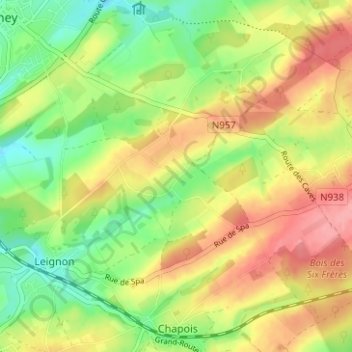
Name: Linciaux topographic map, elevation, terrain.
Location: Linciaux, Ciney, Dinant, Namur, Wallonie, 5590, Belgique (50.25839 5.11204 50.29839 5.15204)
Average elevation: 293 m
Minimum elevation: 248 m
Maximum elevation: 341 m
Thank you for supporting this site ❤️
Make a donation
Make a donation
Other topographic maps
Click on a map to view its topography, its elevation and its terrain.
Chevetogne
Belgique > Namur > Dinant > Ciney
Chevetogne est situé à 19 km de Dinant et à 10 km de Ciney. Le point culminant est situé à Ronvaux à 317 mètres d'altitude (au lieu-dit le Tige de Ronvaux). Le sol est argilo-calcaire et schisteux. Le village compte 75 hectares de bois et est exclusivement agricole. Chevetogne est arrosé par l'Iwoigne,…
Average elevation: 282 m
Thank you for supporting this site ❤️
Make a donation
Make a donation