
Jamagne topographic map
Interactive map
Click on the map to display elevation.
About this map
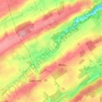
Name: Jamagne topographic map, elevation, terrain.
Location: Jamagne, Marchin, Huy, Liège, Wallonie, 4570, Belgique (50.43170 5.21175 50.47170 5.25175)
Average elevation: 233 m
Minimum elevation: 164 m
Maximum elevation: 281 m
Other topographic maps
Click on a map to view its topography, its elevation and its terrain.
Grand-Marchin
Belgique > Liège > Huy > Marchin
Grand-Marchin, Marchin, Huy, Liège, Wallonie, 4570, Belgique
Average elevation: 225 m
Ronheuville
Belgique > Liège > Huy > Marchin
Ronheuville, Marchin, Huy, Liège, Wallonie, 4570, Belgique
Average elevation: 212 m