
Utelle topographic map
Interactive map
Click on the map to display elevation.
About this map
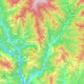
Name: Utelle topographic map, elevation, terrain.
Average elevation: 844 m
Minimum elevation: 133 m
Maximum elevation: 2,054 m
Other topographic maps
Click on a map to view its topography, its elevation and its terrain.
Rigaud
Frankreich > Provence-Alpes-Côte d'Azur > Seealpen
Rigaud, Nizza, Seealpen, Provence-Alpes-Côte d'Azur, Metropolitanes Frankreich, 06260, Frankreich
Average elevation: 1,073 m
Le Suquet
Frankreich > Provence-Alpes-Côte d'Azur > Seealpen > Lantosque
Le Suquet, Lantosque, Nizza, Seealpen, Provence-Alpes-Côte d'Azur, Metropolitanes Frankreich, 06450, Frankreich
Average elevation: 669 m
Roquefort-les-Pins
Frankreich > Provence-Alpes-Côte d'Azur > Seealpen > Roquefort-les-Pins
Roquefort-les-Pins, Grasse, Seealpen, Provence-Alpes-Côte d'Azur, Metropolitanes Frankreich, 06330, Frankreich
Average elevation: 206 m