
Napa topographic map
Interactive map
Click on the map to display elevation.
About this map
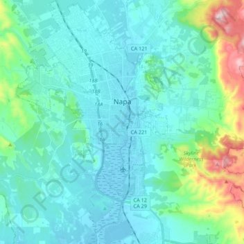
Name: Napa topographic map, elevation, terrain.
Location: Napa, Napa County, Californie, États-Unis d'Amérique (38.22098 -122.35772 38.35083 -122.22220)
Average elevation: 92 m
Minimum elevation: -4 m
Maximum elevation: 568 m
Other topographic maps
Click on a map to view its topography, its elevation and its terrain.
American Canyon
États-Unis d'Amérique > Californie > Napa County
American Canyon, Napa County, Californie, 94503, États-Unis d'Amérique
Average elevation: 48 m
Yountville
États-Unis d'Amérique > Californie > Napa County
Yountville, Napa County, Californie, États-Unis d'Amérique
Average elevation: 68 m