
Ebelsberg topographic map
Interactive map
Click on the map to display elevation.
About this map
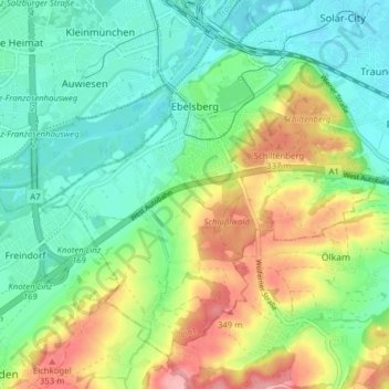
Name: Ebelsberg topographic map, elevation, terrain.
Location: Ebelsberg, Linz, Oberösterreich, Österreich (48.21137 14.28950 48.25476 14.36772)
Average elevation: 288 m
Minimum elevation: 247 m
Maximum elevation: 365 m
Other topographic maps
Click on a map to view its topography, its elevation and its terrain.
Froschberg
Österreich > Oberösterreich > Linz
Froschberg, Linz, Oberösterreich, 4022, Österreich
Average elevation: 296 m
Schiltenberg
Österreich > Oberösterreich > Linz
Schiltenberg, Linz, Oberösterreich, 4032, Österreich
Average elevation: 298 m
Pöstlingberg
Österreich > Oberösterreich > Linz
Pöstlingberg, Linz, Oberösterreich, 4048, Österreich
Average elevation: 392 m
Urfahr
Österreich > Oberösterreich > Linz
Urfahr, Linz, Oberösterreich, Österreich
Average elevation: 297 m
Innere Stadt
Österreich > Oberösterreich > Linz
Innere Stadt, Linz, Oberösterreich, Österreich
Average elevation: 272 m
Bergschlößl
Österreich > Oberösterreich > Linz
Bergschlößl, 1, Bergschlößlgasse, Froschberg, Linz, Oberösterreich, 4020, Österreich
Average elevation: 288 m
Linzer Schloss
Österreich > Oberösterreich > Linz
Linzer Schloss, 1, Schlossberg, Altstadtviertel, Innere Stadt, Linz, Oberösterreich, 4020, Österreich
Average elevation: 286 m