
Wesembeek topographic map
Interactive map
Click on the map to display elevation.
About this map
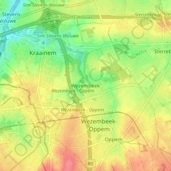
Name: Wesembeek topographic map, elevation, terrain.
Average elevation: 65 m
Minimum elevation: 31 m
Maximum elevation: 97 m
Other topographic maps
Click on a map to view its topography, its elevation and its terrain.
Château d'Ophem
Belgique > Brabant flamand > Hal-Vilvorde > Wezembeek-Oppem > Ophem
Château d'Ophem, Rue Raymond Hernalsteen, Ophem, Wezembeek-Oppem, Hal-Vilvorde, Brabant flamand, 1970, Belgique
Average elevation: 75 m