
Make a donation
Western Cape topographic map
Click on the map to display elevation.
Make a donation
Western Cape
The province is topographically exceptionally diverse. Most of the province falls within the Cape Fold Belt, a set of nearly parallel ranges of sandstone folded mountains of Cambrian-Ordovician age (the age of the rocks is from 510 to about 330 million years ago; their folding into mountains occurred about 350 to about 270 million years ago). The height of the mountain peaks in the different ranges varies from 1000 m to 2300 m. The valleys between ranges are generally very fertile, as they contain the weathered loamy soils of the Bokkeveld mudstones (see the diagrams below).
Make a donation
About this map
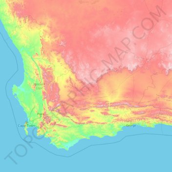
Name: Western Cape topographic map, elevation, terrain.
Location: Western Cape, South Africa (-35.03376 17.56879 -30.43026 24.22241)
Average elevation: 581 m
Minimum elevation: 0 m
Maximum elevation: 2,197 m
Make a donation
Other topographic maps
Click on a map to view its topography, its elevation and its terrain.
Wellington
South Africa > Western Cape > Cape Winelands District Municipality > Drakenstein Local Municipality
Stretching for approximately 18 kilometers (11 miles), the pass rises to an altitude of 595 meters (1,952 feet) at its highest point. It winds through rugged mountains, offering spectacular vistas of the surrounding valleys, rivers, and fynbos-covered landscapes. The route is popular with tourists, cyclists,…
Average elevation: 168 m
Make a donation
Mtubatuba
South Africa > KwaZulu-Natal > Umkhanyakude District Municipality > Mtubatuba Local Municipality
Average elevation: 64 m