
Thank you for supporting this site ❤️
Make a donation
Make a donation
Bashkortostan topographic map
Click on the map to display elevation.
Thank you for supporting this site ❤️
Make a donation
Make a donation
About this map
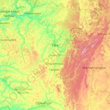
Name: Bashkortostan topographic map, elevation, terrain.
Location: Bashkortostan, Volga Federal District, Russia (51.56955 53.15754 56.53461 60.00181)
Average elevation: 289 m
Minimum elevation: 50 m
Maximum elevation: 1,602 m
Thank you for supporting this site ❤️
Make a donation
Make a donation
Other topographic maps
Click on a map to view its topography, its elevation and its terrain.
Thank you for supporting this site ❤️
Make a donation
Make a donation
Thank you for supporting this site ❤️
Make a donation
Make a donation
Thank you for supporting this site ❤️
Make a donation
Make a donation
Thank you for supporting this site ❤️
Make a donation
Make a donation