
Olinda topographic map
Interactive map
Click on the map to display elevation.
Olinda
The average elevation is 16 m above sea level. The landscapes is made of plains and hills, some of them steep. Olinda is mostly drained by the Paratibe River (55.13% of the territory), with the remainder drained by the Capibaribe River.[6] The municipality is in the Atlantic Forest ecoregion.
About this map
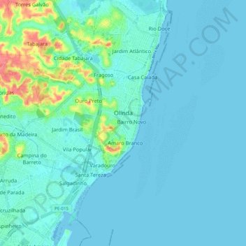
Name: Olinda topographic map, elevation, terrain.
Average elevation: 9 m
Minimum elevation: -2 m
Maximum elevation: 64 m