
Gordon topographic map
Interactive map
Click on the map to display elevation.
About this map
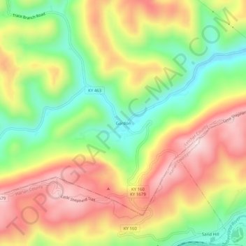
Name: Gordon topographic map, elevation, terrain.
Location: Gordon, Letcher County, Kentucky, 40823, United States (36.97287 -83.04433 37.01287 -83.00433)
Average elevation: 587 m
Minimum elevation: 376 m
Maximum elevation: 803 m
Other topographic maps
Click on a map to view its topography, its elevation and its terrain.
Jenkins
United States > Kentucky > Letcher County
Jenkins, Letcher County, Kentucky, 41517, United States
Average elevation: 590 m
Fleming-Neon
United States > Kentucky > Letcher County
Fleming-Neon, Letcher County, Kentucky, United States
Average elevation: 489 m
Roxana
United States > Kentucky > Letcher County
Roxana, Letcher County, Kentucky, 41832, United States
Average elevation: 425 m
Whitesburg
United States > Kentucky > Letcher County
Whitesburg, Letcher County, Kentucky, United States
Average elevation: 446 m
Dunham
United States > Kentucky > Letcher County > Jenkins
Dunham, Jenkins, Letcher County, Kentucky, 41835, United States
Average elevation: 563 m
McRoberts
United States > Kentucky > Letcher County
McRoberts, Letcher County, Kentucky, 41835, United States
Average elevation: 572 m
Neon
United States > Kentucky > Letcher County > Fleming-Neon > Neon
Neon, Fleming-Neon, Letcher County, Kentucky, 41840, United States
Average elevation: 486 m
Ermine
United States > Kentucky > Letcher County > Ermine
Ermine, Letcher County, Kentucky, 41837, United States
Average elevation: 447 m
Eolia
United States > Kentucky > Letcher County
Eolia, Letcher County, Kentucky, 40826, United States
Average elevation: 612 m