
Jinotega topographic map
Interactive map
Click on the map to display elevation.
About this map
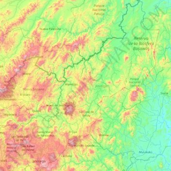
Name: Jinotega topographic map, elevation, terrain.
Location: Jinotega, Nicaragua (12.99428 -86.26151 14.61351 -84.82766)
Average elevation: 524 m
Minimum elevation: 47 m
Maximum elevation: 1,839 m
The city of Jinotega "Las Brumas" is the departmental capital of the homonymous department with an urban population of 53 265 inhabitants in the year 2017. It is located in a valley at an altitude of 1,003.87 meters above sea level with a cool climate at an average temperature of 25 °C and a distance of 142 km from Managua (2h 44 min, by Carr.Panamericana / Panamericana Nte./CA-1).
Other topographic maps
Click on a map to view its topography, its elevation and its terrain.
Comarca Los Amadores Ubú Norte
Comarca Los Amadores Ubú Norte, Municipio de Paiwas, South Caribbean Coast Autonomous Region, 83200, Nicaragua
Average elevation: 252 m
Bluefields
Nicaragua > South Atlantic Autonomous Region > Bluefields
Bluefields, Bluefields (Municipio), South Atlantic Autonomous Region, 81000, Nicaragua
Average elevation: 4 m
Lake Managua
Lake Managua, Nagarote (Municipio), Leon, 22200, Nicaragua
Average elevation: 101 m