
Thank you for supporting this site ❤️
Make a donation
Make a donation
Basta Tahta topographic map
Click on the map to display elevation.
Thank you for supporting this site ❤️
Make a donation
Make a donation
About this map
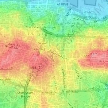
Name: Basta Tahta topographic map, elevation, terrain.
Location: Basta Tahta, Bashura, Beirut Governorate, Lebanon (33.88540 35.50017 33.89017 35.50849)
Average elevation: 58 m
Minimum elevation: -1 m
Maximum elevation: 115 m
Thank you for supporting this site ❤️
Make a donation
Make a donation