
Make a donation
Ebenezer topographic map
Click on the map to display elevation.
Make a donation
About this map
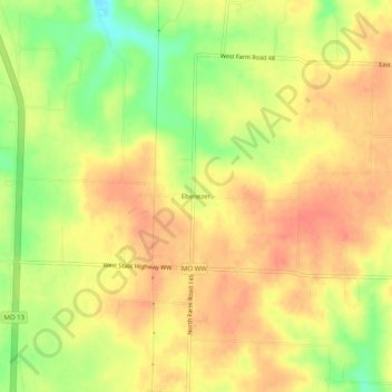
Name: Ebenezer topographic map, elevation, terrain.
Location: Ebenezer, Greene County, Missouri, United States (37.32032 -93.32713 37.36032 -93.28713)
Average elevation: 380 m
Minimum elevation: 346 m
Maximum elevation: 400 m
Make a donation
Other topographic maps
Click on a map to view its topography, its elevation and its terrain.
Springfield
United States > Missouri > Greene County
Springfield is situated on a gently rolling plateau at an average elevation of approximately 1,310 feet (400 meters) above sea level. The region is characterized by a mix of flatlands and gradual slopes that rise toward the nearby Ozark Mountains, which can be found to the south and east. The local terrain…
Average elevation: 389 m
Strafford
United States > Missouri > Greene County
According to the United States Census Bureau, the city has a total area of 2.63 square miles (6.81 km2), all land. USGS Department of the Interior Original Survey 1838 and USGS Topographical Maps show the town along the White River Road that became the Telegraph Road to Saint Louis.
Average elevation: 437 m
Make a donation
Make a donation